Seychelles MSP
Overview
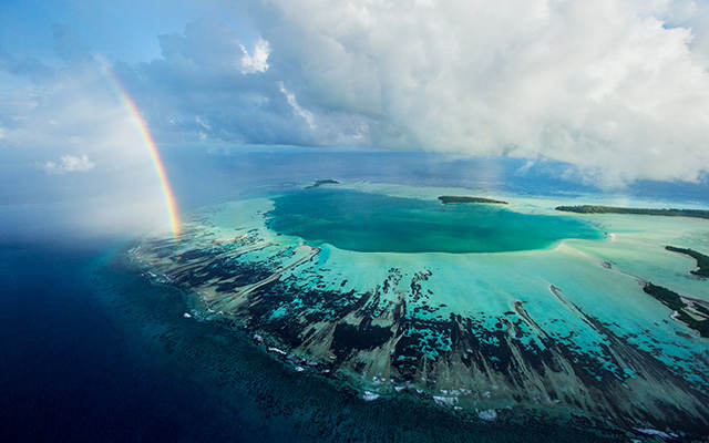
The Republic of Seychelles is an archipelago of 115 islands within a rich tropical marine ecosystem in the Western Indian Ocean. The Seychelles’ Exclusive Economic Zone and Territorial Sea are 1.35 million square km, with a land area of only 455 square km. The island ecosystems have high rates of species endemism and their global importance for marine biodiversity is highlighted by Aldabra Atoll, a UNESCO World Heritage Site. The marine waters support thousands of species of fish as well as regionally significant populations of seabirds and marine mammals. The cold-water upwelling to the Mahe Plateau supports a rich ecosystem of sharks, pelagic fish, cetaceans and invertebrates.
Tourism and tuna fisheries are both vitally important to the economy, and Seychelles is a valuable partner in regional and global trade through shipping and international port facilities in Victoria on Mahe Island. The dropoff habitats leading from the Mahe Plateau are excellent for the local sport fishing and marine charter operators and are also important for the semi-industrial longline and artisanal fisheries. Seychelles and foreign-owned tuna fishing vessels harvest four species of tuna in Seychelles’ waters using purse seine and longline vessels. The unique geology of Seychelles is of interest to the petroleum sector, and seismic surveys have been undertaken to explore oil and gas potential.
Like other small island developing states (SIDS), Seychelles is concerned about the effects that increased storm frequency and rising sea levels may have on coastal areas. In addition, coral bleaching from warm ocean temperatures dating back to the late 1980s threatens the beautiful coral reefs that provide valuable ecosystem services for people and their livelihoods, including artisanal fisheries and tourism. The Blue Economy Roadmap is important for Seychelles to support its sustainable development goals, diversify its economy, and address climate change adaptation and ocean management.
In 2012, Seychelles committed to a 30% marine protection goal for its waters and 50% for terrestrial islands. In 2014, the government began the process of developing a comprehensive marine spatial plan with facilitation and process leadership from The Nature Conservancy. TNC’s leadership for the MSP process includes process design, facilitation, stakeholder engagement, science and technical work, communications, spatial zoning, and implementation plan.
In 2016, the Republic of Seychelles, in partnership with TNC and Paris Club creditors, completed the world’s first marine debt conversion aimed at ocean conservation and climate change adaptation. The marine plan will ensure representative species and habitats have long-term protection, resiliency of coastal ecosystems with a changing climate, and ensure economic opportunities for fisheries, tourism and other uses by advancing the Seychelles’ Blue Economy Roadmap. The Seychelles MSP process is the second largest in the world by area, and will be the first comprehensive MSP in the Western Indian Ocean.
TNC’s Role
- Financing
- Planning tools and spatial analysis
- Process design and facilitation
- Project management
- Science and technical expertise
- Stakeholder engagement
Project Partners
Lead Authority: Government of Seychelles
Facilitation: The Nature Conservancy
Other Partners: Government of Seychelles – UNDP GEF Programme Coordinating Unit, Seychelles Conservation and Climate Adaptation Trust (SeyCCAT)
Status
Phase 1 of the Seychelles MSP Initiative began in February 2014 and was completed in February 2018. Phase 1 included Milestone 1 and a marine protection goal of 15%. Two new marine protection areas were gazetted and officially designated: Zone 1 – Aldabra Group and Zone 2 – Amirantes to Fortune Bank. Zone 1 is for high biodiversity protection and Zone 2 is for medium biodiversity protection and sustainable uses. Milestone 1 covers more than 210,000 sq km (81,000 sq miles). Milestone 1 was 16.1% by area.
Phase 2 began in March 2018, with two Milestones, both 7.5% by area and representation to complete the 30% goal set by Government of Seychelles in 2014. Milestone 2 was held from March to October 2018 and new marine protections gazetted in April 2019 for 26% in marine protections. Milestone 3 was from March to October 2019 and new marine protections gazetted on 26 March 2020 to meet the 30% marine protection target. The remaining 70% of the ocean will be addressed through the completion of the Marine Spatial Plan.
Zoning to Implementation began in 2021. A legal roadmap was developed for a legally enforceable Marine Spatial Plan and an MSP implementation authority operationalized starting in 2022, the Seychelles Ocean Agency (SOA). The Marine Spatial Plan completion is planned for 2024, with implementation of the zoning areas to begin in 2025. The government is developing the necessary steps so that the MSP will be legally enforceable.
Fact Sheets and Project Links
Contact
Joanna Smith, Ph.D., R.P.Bio
Seychelles MSP Process and Science Lead
The Nature Conservancy, Canada (Nature United)
Email: joanna_smith@tnc.org
Helena Sims, B.Sc.(Hons.)
Seychelles MSP Project Manager
The Nature Conservancy, Africa
Email: helena.sims@tnc.org
Photo credit: © Thomas P. Peschak/National Geographic Creative