
[accordion]
[toggle name=”Washington CMSP”]
Washington CMSP
The State of Washington enacted legislation for marine spatial planning in March 2010 (RCW 43.372, amended in 2012). In this law, the Legislature directed the Governor’s Office to chair an interagency team to produce recommendations on how to implement marine spatial planning and establish a framework for the process. The law explicitly identifies renewable offshore energy and marine conservation as primary management objectives to be addressed. The State Ocean Caucus, an existing interagency coordination body that had previously developed Washington’s Ocean Action Plan (2006), played this role and put the framework in place early in 2011.
The framework laid out many of the basic needs for planning, but it did not establish a timeline or budget for the planning process. It also identified some fundamental gaps in the data available to support marine spatial planning. The Nature Conservancy and Ecotrust proposed a pilot-scale project to help familiarize people in Washington with marine spatial planning, provide a platform for some statewide data development, and develop a web-based planning tool with specific functionality to explore different spatial design criteria and address trade-offs between renewable energy and marine conservation management objectives. The planning tool is called Washington Marine Planner. The Conservancy and Ecotrust secured private funding for the project and, through conversations with interested stakeholders and state officials, chose Pacific County as the place to begin.
[/toggle]
[toggle name=”Marine Resource Management”]
Marine Resource Management
Washington has unique governance and advisory structures and processes that make multiple management objective coastal and marine spatial planning (CMSP) an especially appropriate tool for marine resource management. Two of these structures—Shoreline Master Programs (SMP) and county-level Marine Resource Committees (MRC)—provided important enabling conditions for the pilot project.
Washington was the first state to achieve a federally approved Coastal Zone Management Program (1976), which was based largely on its earlier Shoreline Management Act (1971). The Department of Ecology, which manages the state’s Coastal Zone Management Program, is also the lead agency for marine spatial planning. Shoreline Master Programs are local land use policies and regulations created through partnerships between municipal governments (typically cities and counties) and the Department of Ecology. They are designed to protect natural resources, provide for access to public waters and shores, and plan for water-dependent uses.
Washington communities are currently engaged in a multi-year effort to update their Shoreline Master Programs. Over 260 local programs must be updated by 2014. (Both marine and freshwater shorelines are managed under the programs.) Pacific County will be among the last to complete the process, so the pilot project provided a timely approach to get started.
Members of the Pacific County Marine Resource Committee are strong proponents for CMSP. They helped craft the state enabling legislation and turned out for workshops and public meetings on the topic, including a National Ocean Policy listening session in Ocean Shores, Washington. They were consistent in pointing to CMSP as a means for stakeholders and interest groups to contribute directly to ocean management decisions. Washington Marine Planner facilitates that kind of engagement.
[/toggle]
[toggle name=”Pacific County”]
Pacific County
The Pacific County pilot project will help fulfill an important need for their Shoreline Master Program update. One of the early steps in the process is to develop a Shoreline Inventory, Analysis and Characterization. Over the past several years The Nature Conservancy, along with close partners on the coasts of California, Oregon and Washington, has developed regional databases on coastal, nearshore and offshore marine environments. This includes the ecological and social aspects of the region, including human infrastructure and marine-dependent uses. The project team relied on these databases to build an initial platform of information to present to the Pacific County MRC. The County identified their coastal development priority issues, which included beach erosion, aquaculture, public access, current shoreline uses, and water quality improvements. This formed the basis for examining what information the existing databases contained and what data needed to be collected to address these issues.
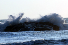
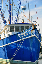
Pacific County is especially dependent on healthy marine ecosystems because commercial fishing and crabbing and shellfish farming are important foundations for the local economy. By placing Washington Marine Planner in the hands of the Marine Resource Committee, the project team anticipates that it will be used to refine the inventory with local knowledge and identify places where there are real or potential conflicts between shoreline land use and important marine resources. This will give county planning staff a stronger start on the update process because the information base will be stronger and important constituents will already be engaged.
[/toggle]
[toggle name=”Washington Marine Planner”]
Washington Marine Planner
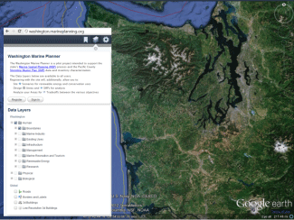 Washington Marine Planner is an online decision support tool to support coastal and marine spatial planning in the state. In the past, consideration of multiple objectives and associated tradeoffs presented an information management challenge, but a new generation of web technologies now provides for managers and stakeholders the ability to interact in real-time with data, management alternatives and each other in ways never before possible. The tool is built on Google Earth, the incredibly fast and high performing mapping technology that can be customized to meet a variety of needs. Planner was designed in response to a real-world planning process, which requires a) spatially-explicit science-based data; b) public participation; c) transparency; d) speed and efficiency; and e) consideration of multiple management objectives. The tool was also developed knowing the process is adaptive, requiring flexibility in response to the specific and changing needs of the process.
Washington Marine Planner serves as a data viewer and planning tool that considers spatial design criteria for multiple management objectives. Data collection, processing, and centralization on the Web offer managers and stakeholders the opportunity to visualize ecological, economic and social attributes of coastal and marine areas in an accessible repository. Shared and transparent access to spatial information that is representative of the management objectives involved in the process is a core component of the Web-based mapping application, from which additional functionality can be built.
Marine Planner users have the ability to summarize ecological and social information, conduct suitability analyses, and consider tradeoffs across management sectors.
[/toggle]
[toggle name=”Uses of Marine Planner”]
Uses of Marine Planner
Site Design: The tool allows users to draw shapes in order to summarize information and identify suitable areas in accordance with renewable energy (tidal, wind, and wave) conservation management objectives. It is also intended to assist the Shoreline Master Program (SMP) process. User-drawn shapes summarize underlying information according to Pacific County priority coastal development issues. These shapes instigate the generation of reports that include easily interpreted graphs and tables. All of the drawn shapes can be saved and shared with other users.
 Suitability/Scenario Analysis: Suitability analyses can be performed by selecting criteria to identify enabling conditions for renewable energy and conservation. Marine Planner walks the user through a series of panels where spatial design criteria can be selected. Once selected, the tool generates shapes on the map that meet those conditions. Results of these suitability analyses can be used to create user-defined proposals, or spatial designs that target specific objectives.
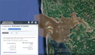
Tradeoff Analysis: Within Washington Marine Planner there are valuation analyses whereby all of Washington State waters contain values or scores for renewable energy and conservation. These scores were generated by examining potential energy sources and adequately representing biodiversity conservation. Methods for these valuations are contained within the tool. By drawing proposals or spatial designs for a specific objective, a summary score will be generated for that area. These areas on the map are again stored and can be compiled together to illustrate potential usage conflicts (shapes that have high valuations for more than one objective are considered conflict areas while those that have high valuations for only one objective do not). The tool provides visualizations that allow for easy identification of such conflicts as well as enabling the user to identify which of their shapes do not have anticipated conflicts with other objectives. Multiple spatial designs are graphed within a “tradeoff collection” for easy interpretation of energy and conservation values.
[/toggle]
[toggle name=”Launch Marine Planner Tool”]
Launch Marine Planner Tool
Disclaimer
The Washington Marine Planner is a pilot project intended to support the state’s marine spatial planning process and the Pacific County Shoreline Master Plan data and inventory characterization.
Marine Planner is owned and operated by The Nature Conservancy and Ecotrust. This website contains a compilation of data sets and is considered preliminary, subject to further change, and intended for informational purposes only. Any draft analysis layers or resulting draft maps produced in Washington Marine Planner are for planning discussion purposes only and should not be construed as approved or decided upon by any state agency or organization involved in the state’s marine planning process. Neither The Nature Conservancy nor Ecotrust warrant or guarantee the quality of the content on this website. Neither organization shall be held liable for improper or incorrect use of the data described and/or contained in Washington Marine Planner. Any sale, distribution, loan, or offering the use of these digital data, in whole or in part, is prohibited without the approval of The Nature Conservancy and Ecotrust. The use of these data to produce other GIS products and services with the intent to sell for a profit is prohibited without the written consent of The Nature Conservancy and Ecotrust. All parties using Washington Marine Planner and/or receiving these data must be informed of these restrictions. The Nature Conservancy and Ecotrust shall be acknowledged as information and/or data contributors to any reports or other products derived from Washington Marine Planner. Users of the decision support tool should also be aware of The Nature Conservancy’s Terms of Use and Website Privacy Policy.
The link below will open the Planner in a separate window. It may take a few seconds to load completely.
[button color=”primary” link=”http://washington.marineplanning.org” target=”_blank” icon=”” icon_position=”right” size=”normal” align=”” fullwidth=”false”]Launch the Marine Planner Tool[/button]
[/toggle]
[/accordion]